Experience
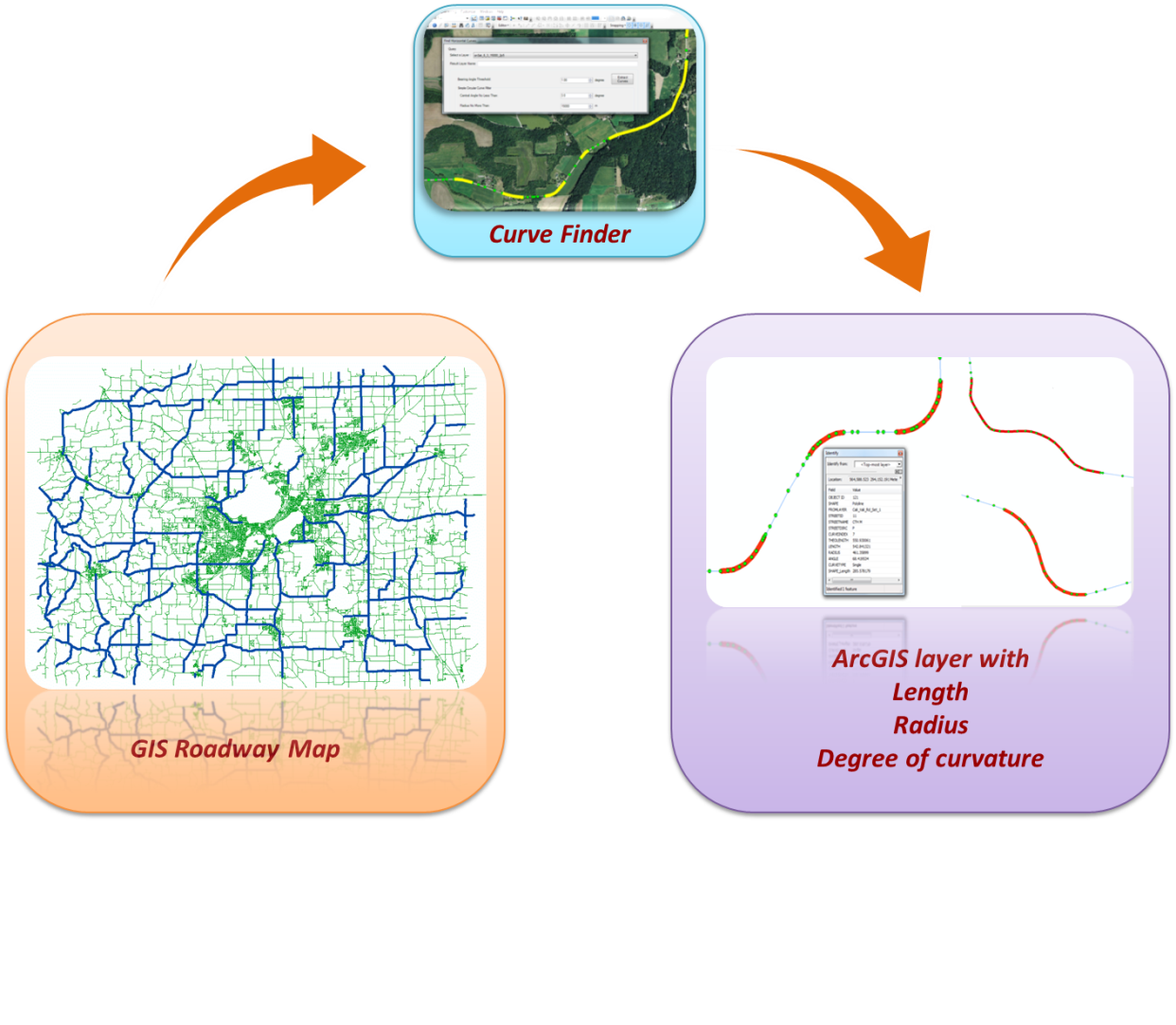
Building on the extensive experience with geographic information systems (GIS), data integration and safety analysis, the University of Wisconsin TOPS Lab developed CurveFinder, a tool to extract horizontal curve location and geometric information automatically from GIS roadway maps. CurveFinder was successfully used in Wisconsin and is being used for extracting curve information for Iowa.
Team
 |
Civil and Environmental Engineering Dr. Noyce will serve as the Principal Investigator. Dr. Noyce is a Professor in the Department of Civil and Environmental Engineering at the University of Wisconsin-Madison (UW-Madison). He has over 28 years of experience in transportation engineering including state government, private consulting, and academia. He is the Director of the Traffic Operations and Safety (TOPS) Laboratory at UW-Madison. The TOPS Lab is currently conducting research in the areas of traffic safety, traffic operations, and technology development. Dr. Noyce has authored more than 150 technical papers, conference proceedings, research reports, and book chapters. His research stimulated the national implementation of the flashing yellow arrow permissive left-turn indication, a fundamental change in traffic signal operations throughout the U.S. Dr. Noyce is very active in TRB, previously chaired the Traffic Control Devices Committee (AHB50), and participated/chaired several NCHRP panels. Dr. Noyce is a member of the Signal Technical Committee, part of the National Committee on Uniform Traffic Control Devices, which oversees the MUTCD. |
 |
Civil and Environmental Engineering Dr. Ran is a professor in the Department of Civil and Environmental Engineering at the University of Wisconsin-Madison (UW-Madison). His research focuses on four major areas: 1) dynamic transportation network modeling and traffic forecasting; 2) Intelligent Transportation System (ITS) technology development and system evaluation; 3) vehicle-highway automation, intelligent vehicles, and Telematics; and 4) applications of information technologies in transportation, including web technologies, GIS, and wireless technologies. Dr. Ran has co-authored two books that summarized his research results, which were published in 1994 and 1996 by Springer-Verlag. Dr. Ran is the Co-PI of WisTransportal. |
 |
Civil and Environmental Engineering Ms. Bill is the Traffic Safety Engineering Research Program Manager with the TOPS Lab at the University of Wisconsin-Madison. She is also pursuing a Ph.D. in Civil Engineering, with an emphasis in traffic safety and operations. Her current research incorporates aspects from each of these disciplines, with a specific emphasis on discovering new and innovative ways to analyze traffic crashes. Andrea received her MSCE from the UW-Madison in 2006, BSCE from the University of Massachusetts, Amherst in 2002 and BA in Physics and Classics from Mount Holyoke College in 2001. She managed several projects which are directly related to roadway infrastructure and safety. |
 |
Civil and Environmental Engineering Dr. Chitturi is an Associate Researcher in the TOPS Lab at UW-Madison and has published 24 articles in peer-reviewed journals, one book, 31 articles in peer-reviewed conferences as well as 23 technical reports. His research spans multiple aspects of traffic operations and safety including signal operations, winter maintenance, intelligent transportation systems, work zone operations, roundabouts, older driver safety, intersection safety, work zone safety, Bluetooth applications in transportation, human factors in crashes and incident management. Dr. Chitturi led the research efforts to develop the Wisconsin Experimental Intersection at the TOPS Lab. Prior to that at the University of Illinois, he built the test bed for evaluating detection systems and performed an evaluation of multiple video detection systems for Illinois DOT. |
 |
Civil and Environmental Engineering Dr. Li is a former Assistant Researcher in the TOPS Lab at UW-Madison. He is the major developer of CurveFinder. His research interests include highway safety, GIS-T, traffic flow theory, ITS, sustainable transportation, traffic simulation, human factors, and transportation policy. Dr. Li has been involved in 15 national and state-level research projects on traffic safety and operations, and is author of 31 journal and conference papers and an ITE handbook chapter. Dr. Li is a member of the NCHRP Project D03-113 panel, TRB Information Systems and Technology committee, and technical committee on Travel Information and Traffic Management of IEEE ITS Society. Dr. Li received his Ph.D. in Civil Engineering from the University of Cincinnati, and B.E. in Electrical Engineering from Sun Yat-sen University in China. |
Related Projects
- Bridge Safety Improvements Prioritization Methodology Development
- Cross Median Hot Spot Analysis
- Data Resource Guide
- Development of Arterial Truck Safety Risk Index
- Evaluation of Wisconsin Median Cable Barrier Systems
- Operation and Safety Impacts of ROR Crashes in Wisconsin: Object Hits and Ramp Terminals
- Safety Evaluation of Horizontal Curves